Flat Earth - Satellite Image Viewer app for iPhone and iPad
4.8 (
1408 ratings )
Travel
Navigation
Developer:
Flat Earth Lab
Free
Current version:
1.4.5, last update: 7 years ago
First release : 10 Dec 2010
App size: 10.15 Mb
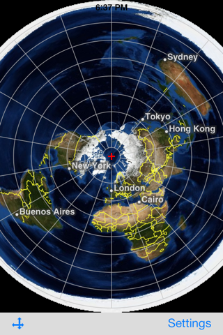
This is an application that displays satellite images of whole earth in Azimuthal Equidistant projection centering on arbitrary points.
Directions:
Double tap: Move the center of projection.
Pan: Translate maps (only in the translation mode). Revolve maps around the center of projection (only in the rotation mode).
Pinch: Zoom in or zoom out on maps (only in the translation mode).
The button on the left side of the toolbar: Switch between the translation and the rotation mode.
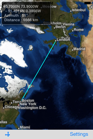
Long Press on the map: Display the shortest path between the center and the long-pressed point. Also, calculate the azimuth clockwise from North and the distance between these points, and show them in a text view. When tap the text view, the text view and the path disappear.
Tap the page curl button in the lower-right corner:
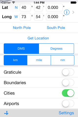
- Show/Hide lines of latitude and longitude.
- Show/Hide boundaries of countries.
- Show/Hide names of major cities.
- Show/Hide major airports. (Their names are visible when zooming in.)
- Center of projection can be specified in either of the following ways:
- entering longitude and latitude manually,
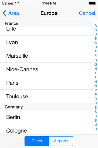
- selecting a city from a list of cities,
- getting the users current location.
- Select the unit of distance: kilometer (km), mile (mi), nautical mile (nm).
This application uses the satellite images obtained from NASAs web site.
The maximum resolution of satellite images in this current version is 4/480 degrees per pixel. This application can be used in offline environment, but will be more limited in resolution.
Credits:
Blue Marble: Next Generation was produced by Reto Stockli, NASA Earth Observatory (NASA Goddard Space Flight Center).
Natural Earth: Free vector map data @ naturalearthdata.com.
Airport data from OurAirports (http://www.ourairports.com/data/).
Pros and cons of Flat Earth - Satellite Image Viewer app for iPhone and iPad
Flat Earth - Satellite Image Viewer app good for
I have been looking for a map projection app for a while, and although only azimuthal, this does exactly what I need, which is this: Instead of plotting for the city of interest, I plot for the point exactly on the other side of the globe from the city of interest. This essentially gives you a view from that city outward at an inside-out earth map that makes it easy to visualize what cities and land masses lie along a particular direction of view. As the outer circle now represents the viewing point you are standing on, rotating the map spins you to view N, E, etc. Every city should have a map like this painted on a roof dome perhaps in a city hall for a unique perspective on its location in the world. Many thanks for making this app! (and including beautiful blue marble monthly imagery as well)
I love the creators of this app!!! I will post a link in my recommendation post in my social media feeds as well!!!
Pretty good little app, I was hoping there would be and AE map app of some sort. If it had jet stream/ weather information it would be really cool.
So its a bit simplistic as is but unique for what it is.
Some bad moments
I believe in flat earth, but this application is providing no information. This application is based on global earth, whenever we click anywhere, it shows 2D version of globe earth model.
This is a great tool for visualizing great circle distances and mapping relations between two points. My only complaint is that it is difficult to set latitude and longitude precisely. The program needs some provision for either manually entering coordinates, selecting a default city, or generating a map around the users current location. This would dramatically increase its utility.
There is an ice wall around this planet 150ft high. NASA has guards around the wall to prevent people from going to the beyond and not to fall off the edge.
And shall the truth of the shape of the earth set you free! ❌❌❌
Gives you a perspective on our world that no other app can offer.
Usually Flat Earth - Satellite Image Viewer iOS app used & searched for
satellite maps,
satellite map,
gps satellite,
and other. So, download free Flat Earth - Satellite Image Viewer .ipa to run this nice iOS application on iPhone and iPad.